Driving coastal Canada near Duffey Lake
There is nothing particularly striking about the above image. It is not an artistic masterpiece or some kind of groundbreaking photograph. In fact, it’s not even in the top 10-20 photos from my Canada and Pacific Northwest adventure from last summer.
However, when I look at it, it brings back the feelings of an amazing adventure I took last summer. A sense of adventure I had that lasted over five days and culminated into a thrilling, yet exhausting 24 hours driving down the Canadian Rockies and across the entirety of southern British Columbia.
However, let’s backtrack a bit. In the summer of 2012, I decided to take a trip up into the Canadian Rockies. My brother joined in, and the two of us would be trekking to some of the most beautiful mountain scenery in the world! I had seen photos of these majestic mountains for years, and what really sold me on them was pictures of Moraine Lake. As I always do, I researched. And I researched some more. I looked through lots of British Columbia and Canadian Rockies travel books. And I mapped locations on Google for weeks. After changing my mind a million times (which is part of my trip planning process – ask my wife, brother or anyone who has traveled with me – they can attest to that), I had formulated a plan. For 10 days, I would trek north from Spokane, Washington, through the beautiful Canadian Rockies and the Icefields Parkway, then make my way west to the Stewart-Cassair Highway and eventually to Hyder, Alaska, where an hour drive straight up into the rugged mountains of southern Alaska would lead me to a view above the mighty Salmon Glacier. While the journey would be half the fun, standing above the Salmon Glacier that straddles the border of southern Alaska and western British Columbia was to be my end destination. Afterwards, we would drive back down through British Columbia and the mountains north of Vancouver, before heading home from Spokane. Ambitious is probably the word that best describes this journey.
We purchased our plane tickets and set our sights on those jagged peaks to the north! Unfortunately, this trip fell victim to tight planning. Too tight. Shortly after buying these plane tickets, we found out that my brother had lost his passport. Because of how soon the trip was, there was no time to have a new one made. Not to mention, the plane tickets were non-refundable. Thankfully, for a fee, we could change the location and time of his departure. I was determined to make it to the Canadian Rockies and the Salmon Glacier. A good sunset, sunrise or night shot of the Salmon Glacier was supposed to be the signature photograph from this trip. Or even better, capturing the Northern Lights (something I’ve still yet to experience in my lifetime) over the giant glacier.
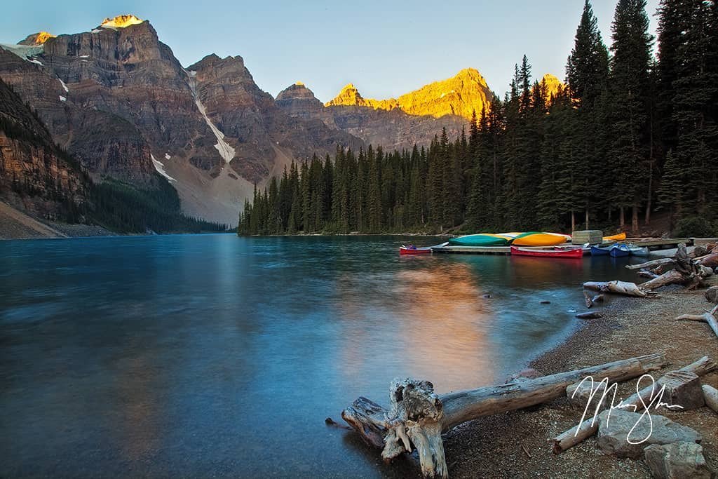
Canoes at Banff’s Moraine Lake: The type of beautiful scenery typical in the Canadian Rockies
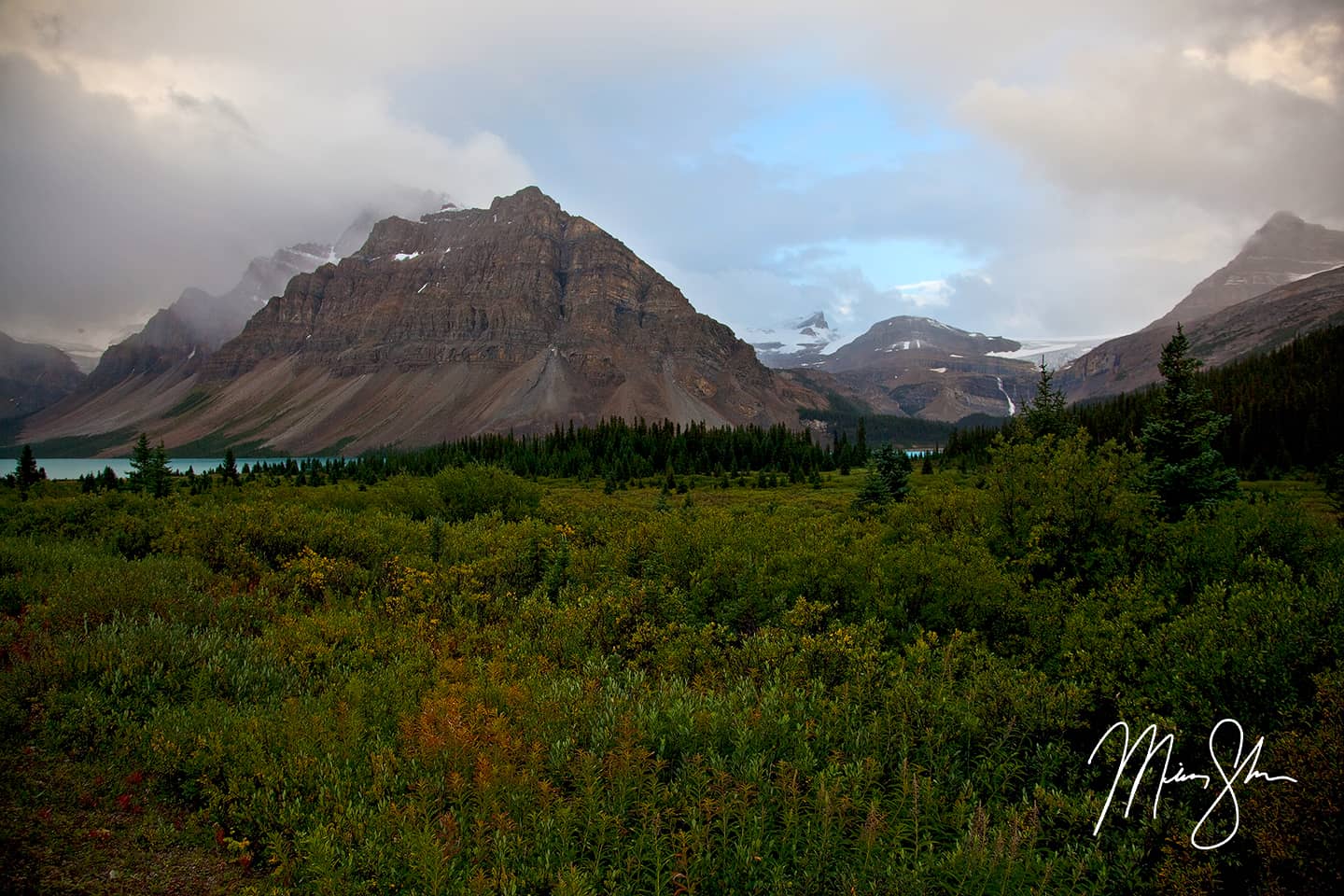
So a new plan was set. I would fly out with the original flights on a Saturday, race up the Canadian Rockies, across central British Columbia to Stewart, Hyder and the Salmon Glacier, then down to Vancouver and across the border where my brother would fly into Bellingham Washington on Wednesday. The rest of the trip would be spent in the Pacific Northwest exploring Washington and Oregon. So five days to drive over 3000 miles and still see and photograph everything. I had already done a similar road trip earlier in the year, and loved it! The challenge was on! The trip was no longer ambitious but almost absurd. I would be lying if I didn’t admit I was nervous about the whole thing. I was about to head up into some extremely rugged and remote places, where emergency services and help are not a phone call away. Not to mention, my main goal of camping out in my rental car above the Salmon Glacier. What if the car broke down? What if I ran into a grizzly bear? The drive in to Stewart and Hyder, Alaska is known for a very large population of both black bears and grizzly bears. Granted, I didn’t plan doing any major hiking alone, but still, I was a bit nervous. But either way, I was determined to do this trip.
Then came the day of the trip. I arrived at the airport, went through security, and within half an hour, a month of planning was shattered in an instant. As I sat waiting to board my early morning flight from Wichita to Spokane, we were informed that the flight was cancelled. Instead of getting to Spokane at 10AM, the re-routing would put me into Spokane around 7PM. Not good. Especially since I had a hotel booked on the edge of Yoho National Park, an 8 hour drive north of Spokane. To make matters worse, I found out the rental car agency closed at 5PM on Saturdays. So I got stuck in a Motel 6 near the Spokane airport until Sunday around noon. I now had three and a half days to pull this off. When I got to the agency, I was informed that the car they had for me was rented out on Saturday and was handed an SUV. Normally an SUV would be fine, but considering the amount of mileage I had to cover in my plans, the cost of gas just sky-rocked. Between having to cancel the few hotels I had booked, having to pay 2x as much for gas in a big SUV, having a day cut out of an already ridiculously ambitious trip along with bad weather rolling into the southern part of Alaska, my dreams of seeing Hyder and the Salmon Glacier evaporated. I came to the realization that this just wasn’t happening. I live for insane road trips. I sometimes feel like the journey of a road trip is just as fun as the final destination. Especially when seeing so much along the way. But driving to the edge of Alaska and back in such a short time… it was too much to pull off in such a short time. I was disappointed, but I had to remind myself that the Canadian Rockies were still within my grasp. The new plan began to take shape. I would use what little time I had to cover Banff, Jasper, Yoho and the Icefields Parkway in as much detail as possible. And that’s the other thing about some of my trips: I don’t sleep much. I’m up for sunrise at some spectacular location. I explore all day. I shoot the sunset, and sometimes even shoot after dark for night shots. And then I repeat the next day.
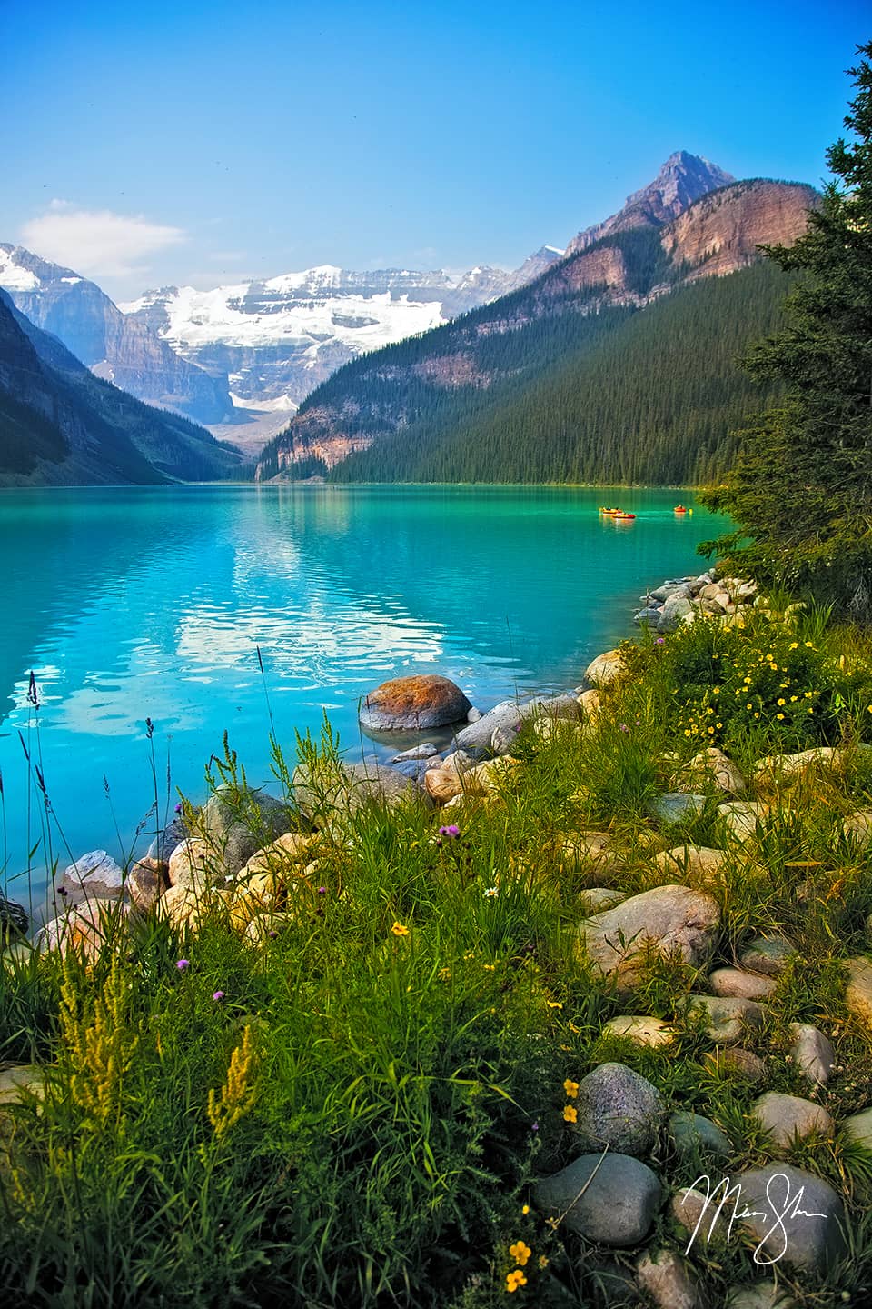
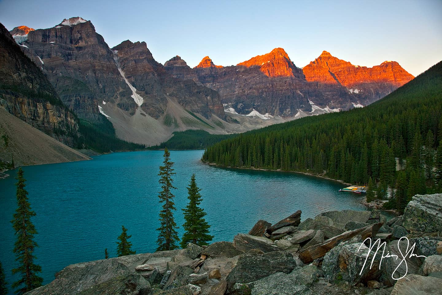
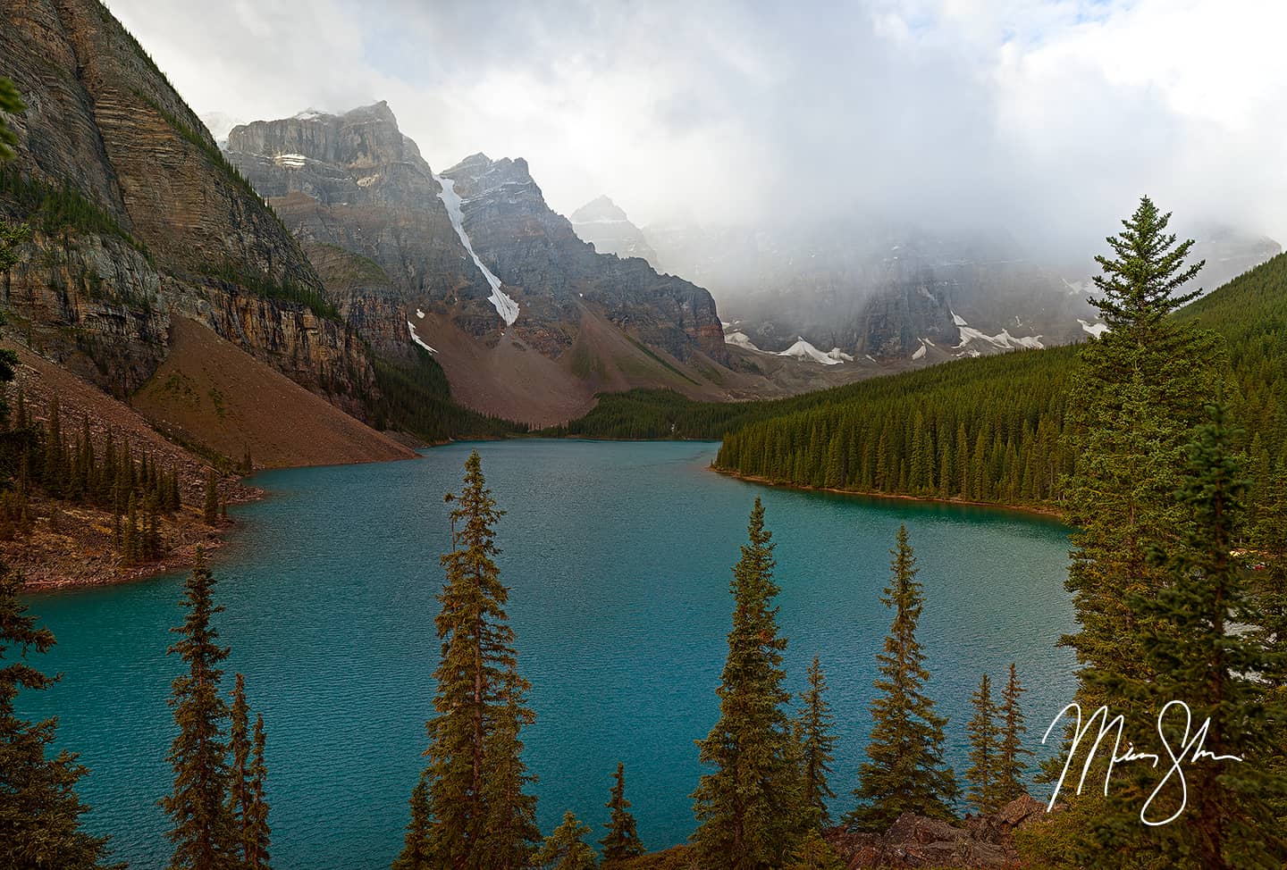
Because I had to rebook hotel rooms, my cost went up. Considerably. While finding accommodations near the national parks in the Canadian Rockies in the middle of summer can be difficult, trying to do it on the cheap is nigh impossible. I stayed in Golden, British Columbia on the west end of Yoho National Park on Sunday night. It was too dark to see much of Yoho by the time I arrived that evening, but I still took a quick drive into the park. It was beautiful and just that simple drive into the mountains washed away all of my disappointment. I was in one of the premier mountain destinations in the world and I had three days to explore and photograph to my hearts content! Early Monday morning, I raced through Yoho across the British Columbia/Alberta border and got to Moraine Lake for sunrise. Moraine Lake can simply be summed up as one of the most beautiful alpine lakes in the world. In fact, I’ve yet to see a lake I’ve found more beautiful. And that includes the gorgeous lakes in Switzerland.
Reflections at Moraine Lake
My first day in the Canadian Rockies
Unfortunately the sunrise was a dud. The cloud-cover was too heavy so the mountains never really lit up. However, it was still beautiful. I snapped a few images at both the classic rockpile vantage-point and from the lakes edge where the canoes were. The best of which is the above shot. These canoes line many of the lakes in the Canadian Rockies. I also just spent some time marveling at how beautiful the scenery was! After Moraine Lake I decided to drive up the Icefields Parkway. My plan was to spend the day exploring it up to Jasper and then head back and stay in Canmore on Monday night. I would then head across part of British Columbia and stay in a cheap motel somewhere between Banff and Vancouver on Tuesday night. Within a few miles of starting down the Icefields Parkway, I looked to my right, and low and behold, a black bear was right on the side of the road, foraging for food!
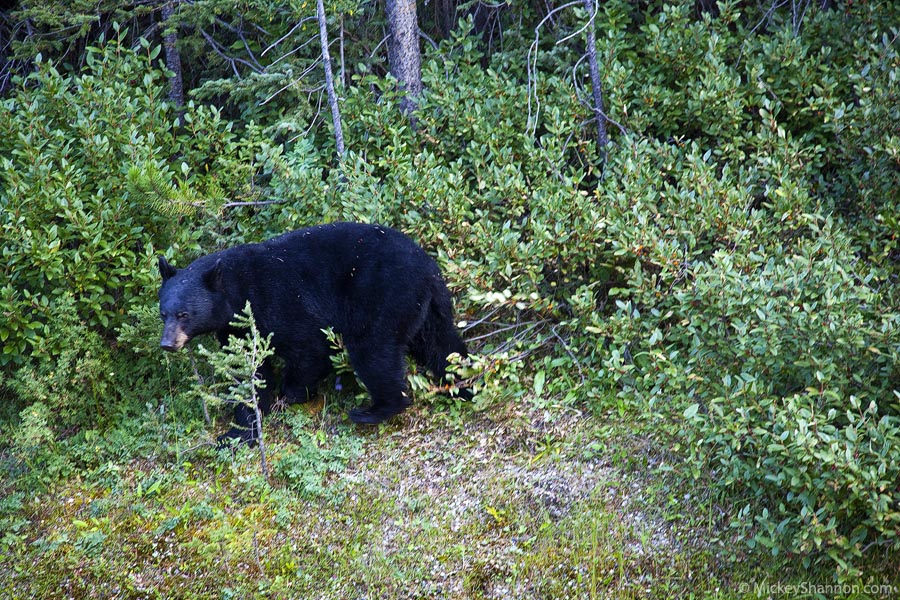
A bear on the side of the road on the Icefields Parkway
After a few more miles up the road, I realized how hazy the atmosphere was. Not good haze, but haze that made shooting at a place like famous Peyto Lake extremely difficult. It also didn’t help that I was sharing it with 100 other tourists from the many tourist buses either. After a while, I gave up and decided I would try to drive up the Icefields Parkway first thing in the morning on Tuesday, then across British Columbia to my motel somewhere closer to crossing the border on Wednesday. But I still had the rest of the day to fill up, so I decided to go back and check out Lake Louise, which is probably the most famous of all the lakes in the Canadian Rockies!
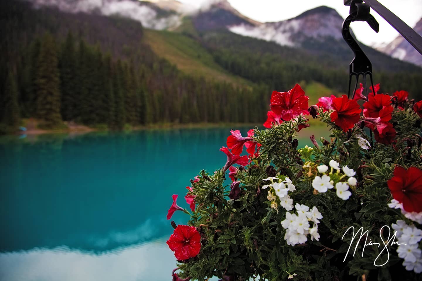
Flowers on the edge of Lake Louise
Lake Louise is right off the main highway and town of the same name. There’s a famous hotel right at the edge of Lake Louise called Fairmont Chateau Lake Louise. A walk along the lake’s eastern end lets you visit the beautifully crafted flowers and gardens of the Fairmont. The farther south you walk around the lake, you come to the many canoes for rent that you can take out onto the turquoise-colored lake.
After spending some time at Lake Louise, I unsuccessfully tried to check into my hotel in Canmore early. I noticed on the drive between Lake Louise and Canmore how there were “wildlife bridges” that went over the highway. These bridges let the wildlife have a natural crossing free of the traffic that created many collisions. It’s a pretty unique idea that Banff National Park has pioneered. You can read more about it on the Wildlife Crossings Research and Monitoring page.
After unsuccessfully checking into my hotel early, I grabbed some Subway and visited Lake Minnewanka to the north of the town of Banff. It was too hazy for any good photography, but it was still a beautiful place to be at. I walked around the lake a bit, then decided I would head to Yoho National Park to see Takakkaw Falls and Emerald Lake before returning to Moraine Lake for a sunset.
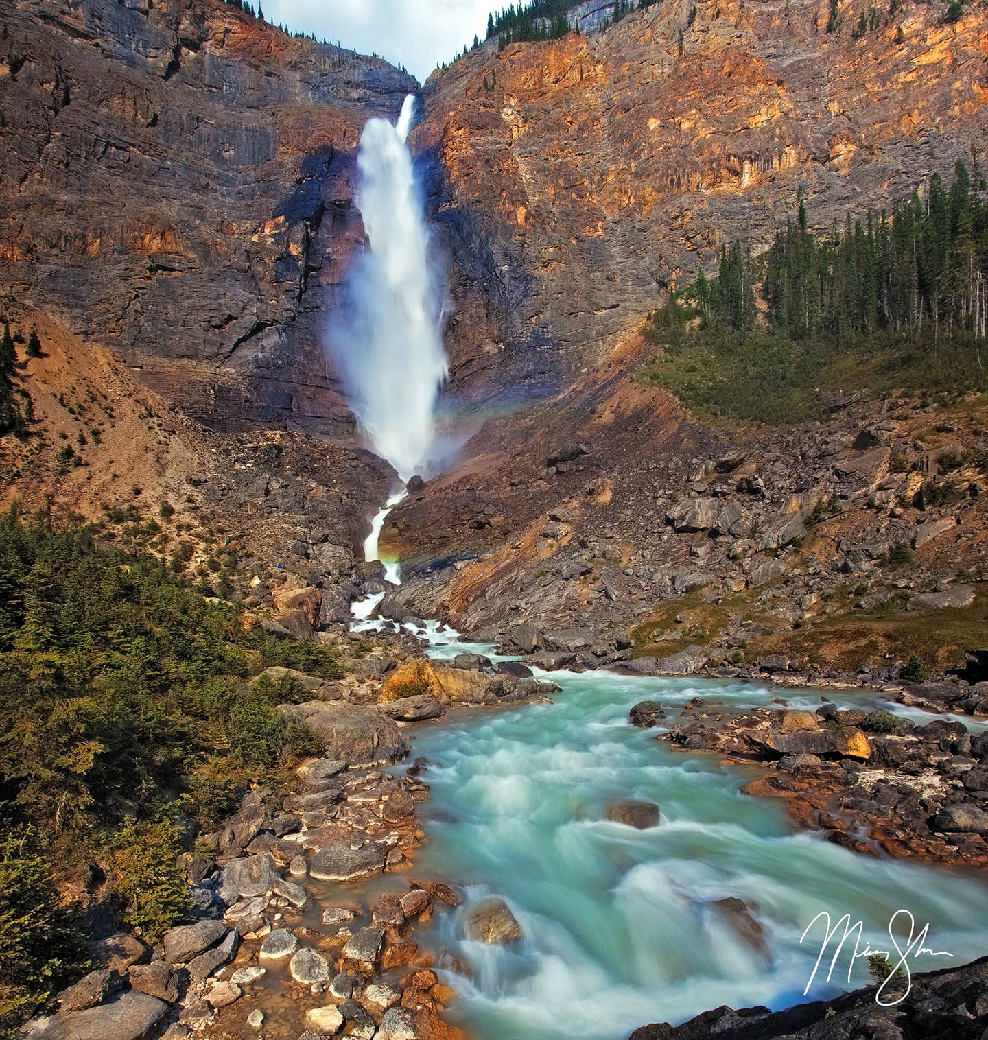
Takakkaw Falls and the cascades below it
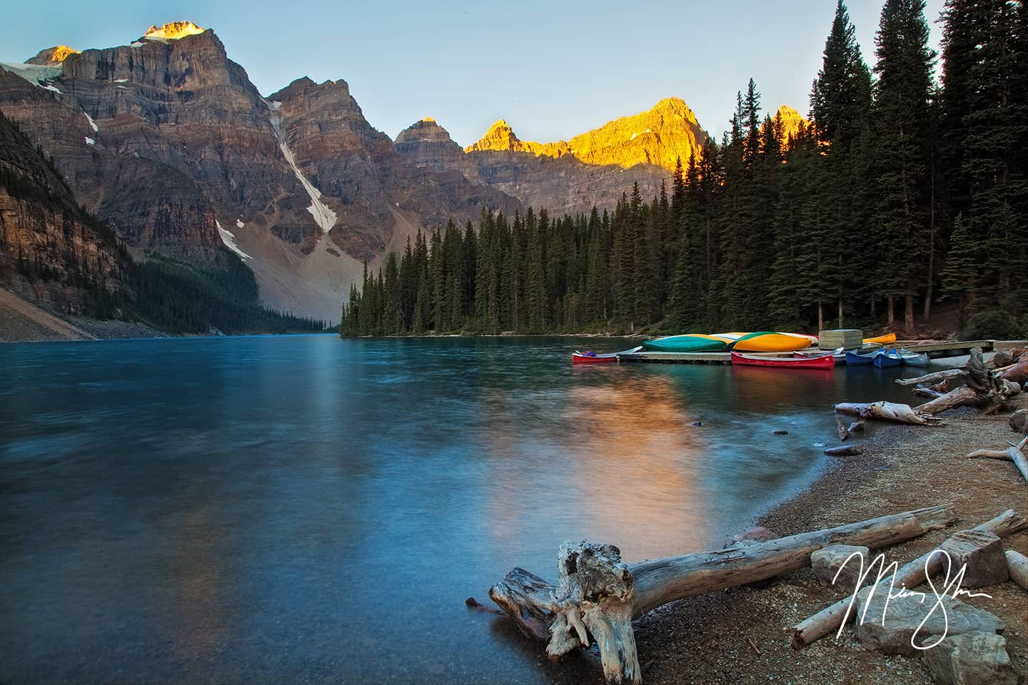
I hiked around beautiful Takakkaw Falls for quite a while, enjoying how beautiful the area was. Takakkaw Falls are almost 1000 feet in height, and the spray carries quite a ways down the valley. It was difficult to shoot, as the sun was almost directly overhead, but I did my best with the shot above. After exploring and photographing with the rest of the tourists, I realized I didn’t have time to make it to Emerald Lake in Yoho if I was to make it back to Moraine Lake for a quality sunset. So I left Takakkaw Falls and drove back to Moraine Lake. This was the best decision I could make, as I got what I consider the best photograph of the trip that evening. There weren’t a lot of clouds, but the lake was fairly calm, the atmosphere and lighting were good, and it was a beautiful evening! After shooting this sunset, I spent a little more time at Moraine Lake and walking around Lake Louise in the final minutes of twilight before heading to Canmore to crash at my hotel.
A beautiful Moraine Lake sunset
The Icefields Parkway
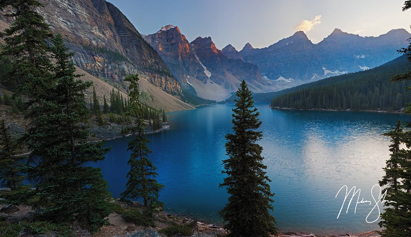
The Valley of Ten Peaks puts on a coat of red alpine glow during a Moraine Lake sunrise
The next morning (Tuesday), I awoke at 4:30AM, checked out, and jumped on the road for Moraine Lake. I needed to be there at sunrise so I could get on the Icefields Parkway quick. I had a long day ahead of myself if I was going to drive up the Icefields Parkway to Jasper, the head most of the way to Vancouver. After a few shots of Moraine Lake, one of which is featured above, I was on my way up the famous Icefields Parkway! If you look up the Icefields Parkway in Google, you’ll find it in most top 10 lists for most beautiful drives in the world. I saw nothing that contradicted this on my drive through Banff and Jasper. It was gorgeous. The drive is full of beautiful lakes, amazing waterfalls, abundant wildlife (I saw what I assume was the same bear from the morning before at the same location the next day!) and the highpoint where the Athabasca Glacier drops down from the massive Columbia Icefield to within walking distance of the highway. As I began my drive, I kept thinking to myself “Why don’t I just sleep in the SUV somewhere near the glacier at a campsite, and make the long drive back Bellingham, Washington all day Wednesday?” By the time I got to the massive Athabasca Glacier, I was convinced this was my plan.
The weather called for clear skies and fairly warm temperatures for a night in the mountains. Perfect. I could get a blanket when I got to Jasper, crash out in the back of the SUV at a campsite half a mile from the Athabasca Glacier and get up around 3AM to shoot some kind of sweet night scene with the glacier as my foreground. Who knows, maybe the Northern Lights would even come out to play. After all, Jasper National Park is known as a Dark Sky Preserve.
With this new plan made, I deposited my money at the Wilcox Creek campground just south of the Columbia Icefield Discovery Center parking lot and started driving north to Jasper to finish off the last half of the Icefields Parkway, stopping at Sunwapta Falls. I didn’t capture anything of note, but the falls were still pretty, if a bit packed with tourists.
The main road through Jasper
Once I arrived at Jasper, I grabbed some lunch and stopped in a small grocery store to get a bottle of tea. The town of Jasper itself was pretty interesting. You can see how it has a rich history in the gold rush to western Canada and Alaska. The entire town had a old west feel to it, and there were many interesting railroad features. Train tracks everywhere, old model rail cars, etc. A highway sign for Prince George and Prince Rupert caught my eye as well, knowing that I should have been going in that direction towards Alaska had my trip not been cut a little short by my flight. I still wonder what kind of beauty lies hundreds of miles to the west, and dream of finishing the trip to Hyder, Alaska and Salmon Glacier. However, I only had an afternoon. So I had a choice to make. I really only had time to go east or west. To the west was Mount Robson Provincial Park. And to the east was the road to Maligne Lake.
I chose the road to Maligne Lake. About halfway down the road to Maligne Lake is Medicine Lake. This lake is unique in that it’s not really a lake at all! During the summer, the Maligne River get’s backed up in this area, creating the river. Eventually the “lake” drains into the ground and returns to being a river. You can see how it looked in the summer when I was there. A few months later, it would have been nothing more than a frozen river in winter.
The view from Medicine Lake
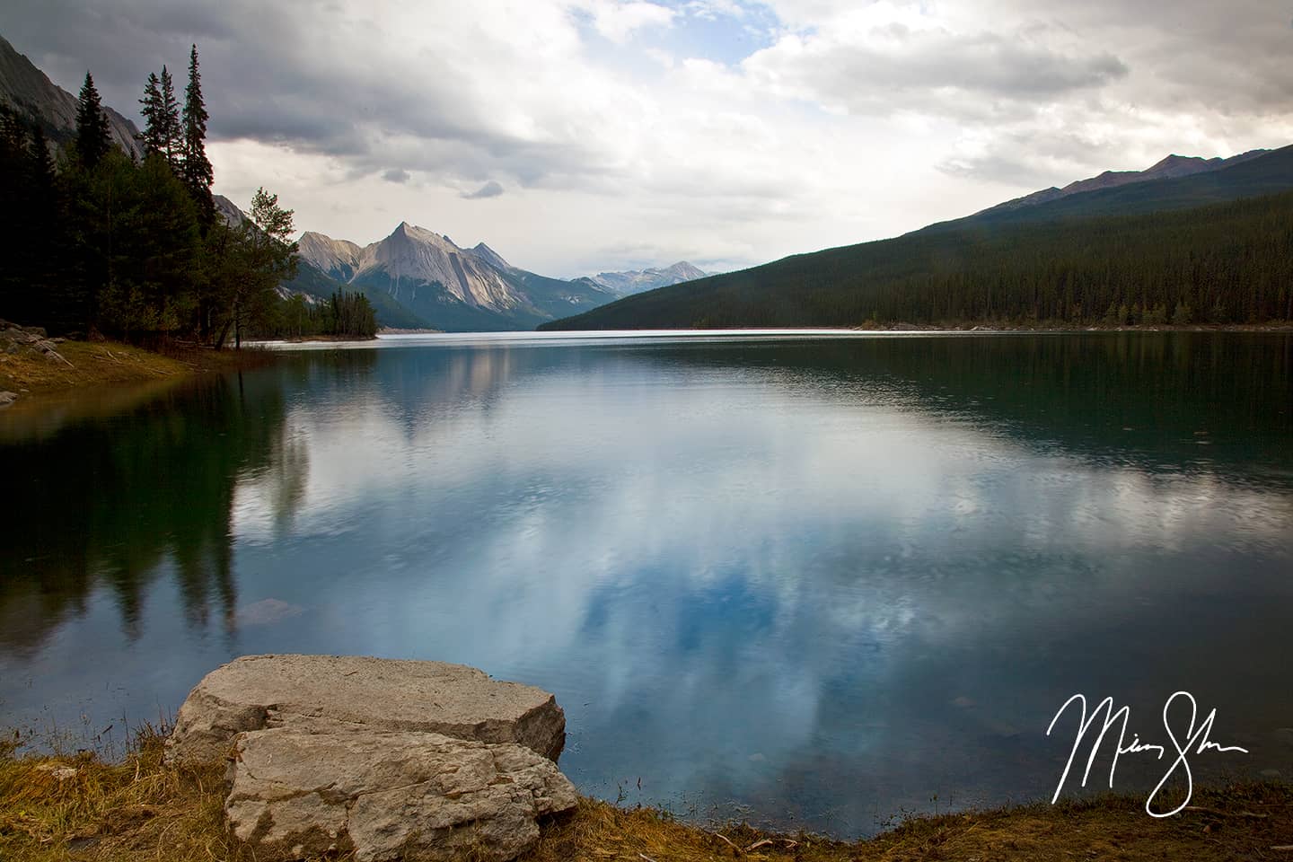
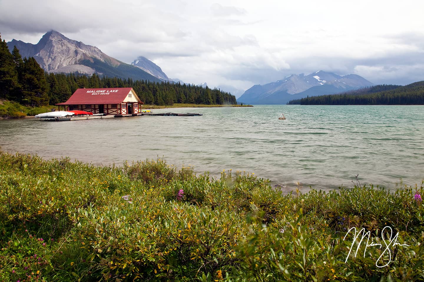
There were quite a few tourists at the stop-off at Medicine Lake so I jumped back into the SUV and kept going south to Maligne Lake. It was raining by this point. As I came around the first bend, a herd of mountain sheep nearly rammed the front of the SUV! I think they were as shocked to see me come around the corner as I was to see them running up the road at me. I would have loved to have snapped a photo of this, but it happened so fast and I was more concerned with just watching out for them as they charged around the vehicle. After watching them pass around, I made my way down to Maligne Lake, by which time it was pouring. Even in the rain, I wandered around for a bit and shot a few photos. The only one that came out okay (and hadn’t tried to soak my lens) is below.
The rains let up for a few seconds at Maligne Lake
I walked around the lake a little more, but the rain kept coming in waves, and so I thought it was time to head back up the Icefields Parkway to get some good evening shots. I really wanted to make sure I was back at the Athabasca Glacier by sunset! As I drove back down the road from Maligne Lake towards Jasper, the clouds began to part and the rain was lifting some. I stopped to shoot a photo of the Maligne River and the mountains to the east. These mountains looked like some kind of backbone. They jut straight up like giant stone slabs. Very unique.

Jagged mountains above the Maligne River north of Maligne Lake
I passed by the town of Jasper and continued south, finally Athabasca Falls, which I had left for the return trip. Unfortunately, the rain in the mountains had turned the usually vivid blue waters into a murkier dull color. Below was the only decent shot from Athabasca Falls that I managed to get.
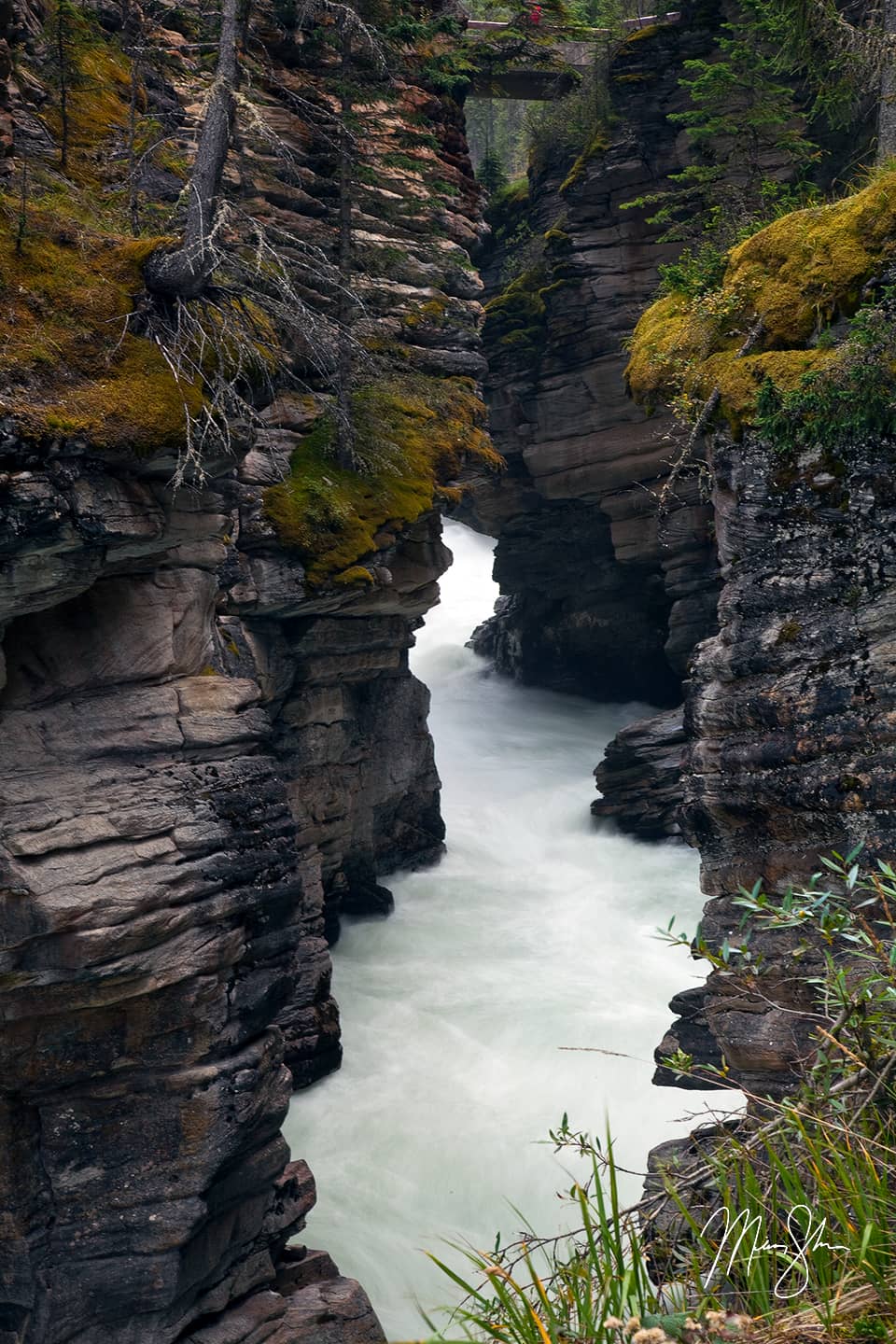
The curvy canyons of Athabasca Falls
After my stop at the Athabasca Falls, I continued back towards my campground at the top, but was greeted by one of the most vivid rainbows I’ve ever seen in my life. As the photo below shows, this rainbow literally looked like it had a pot of gold just over the hill on the road.
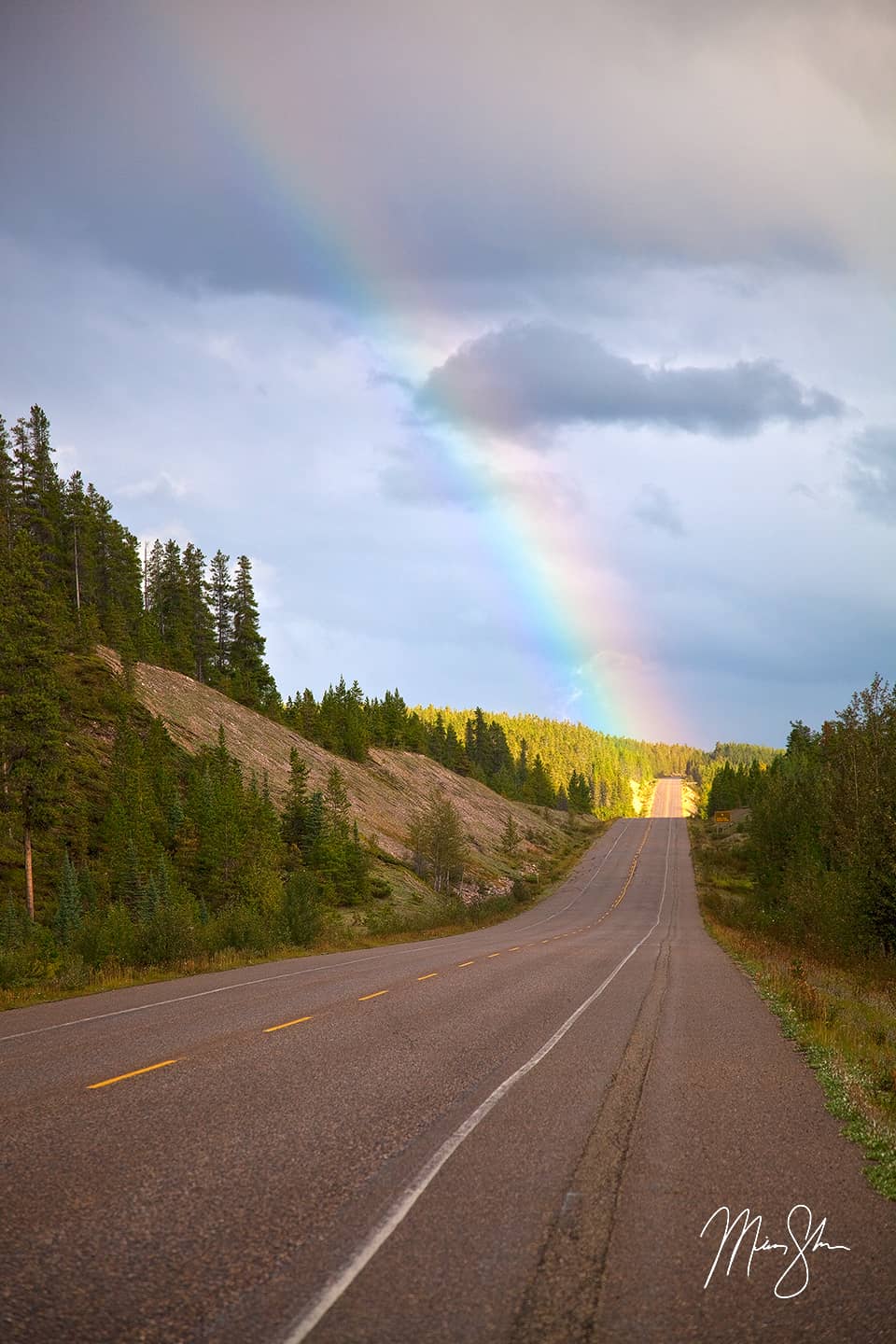
An extremely vivid rainbow lands right on the Icefields Parkway!
I continued, hoping for a pull-off with a view that would give me a great shot of the rainbow. I found the pulloff for Honeymoon Lake, and ran to the edge of the lake, hoping to get a good shot of the rainbow. Unfortunately it had begun to fade, and I couldn’t get my tripod set up and my photo composed before the rainbow was mostly gone. As I walked back to my car, a couple from Edmonton asked where I was from. When I told them Kansas, they were surprised and exclaimed how far I must have driven to get there! I told them I had flown to Spokane and drove up, and they were still impressed. Truthfully, the drive I would have the next day was far more impressive than driving from Spokane a few days before.
I jumped back in the car, and continued back up the mountains, kind of puzzled as to why it was getting cloudier and darker rather than clearer. I was beginning to worry the forecast was completely wrong. By the time I got most of the way back up, I had already given up on a sunset. The clouds had set in and it was beginning to drizzle again. There was little in the way of breaks in the clouds. However, I did discover a waterfall near the top called Tangle Creek Falls that were beautiful! Between most of the daylight having disappeared and the cloudy, drizzly weather, I upped my shutter speed and took a large vertical panorama of the falls. This is one of my favorite photos from the trip! These falls were rushing from all the rain through the day. It seemed like little falls were pouring off of everything!
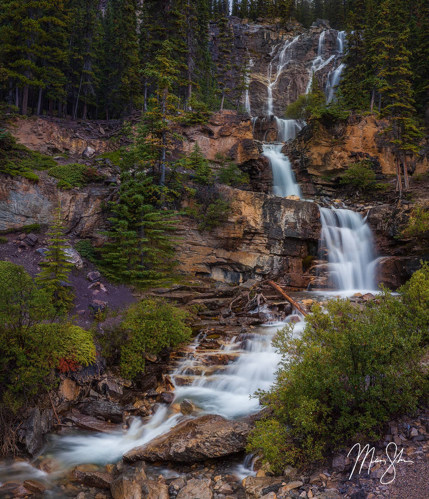
Falls pouring off of every cliff at Tangle Creek Falls
I continued on to the top, where the Athabasca Glacier juts down from the Columbia Icefield. It was well after sunset, into the final minutes of the blue hour. I tried taking shots of the Athabasca Glacier from any angle possible, including the little streams that had developed from the rain. In the end, it was really dark, but I managed the shot below.
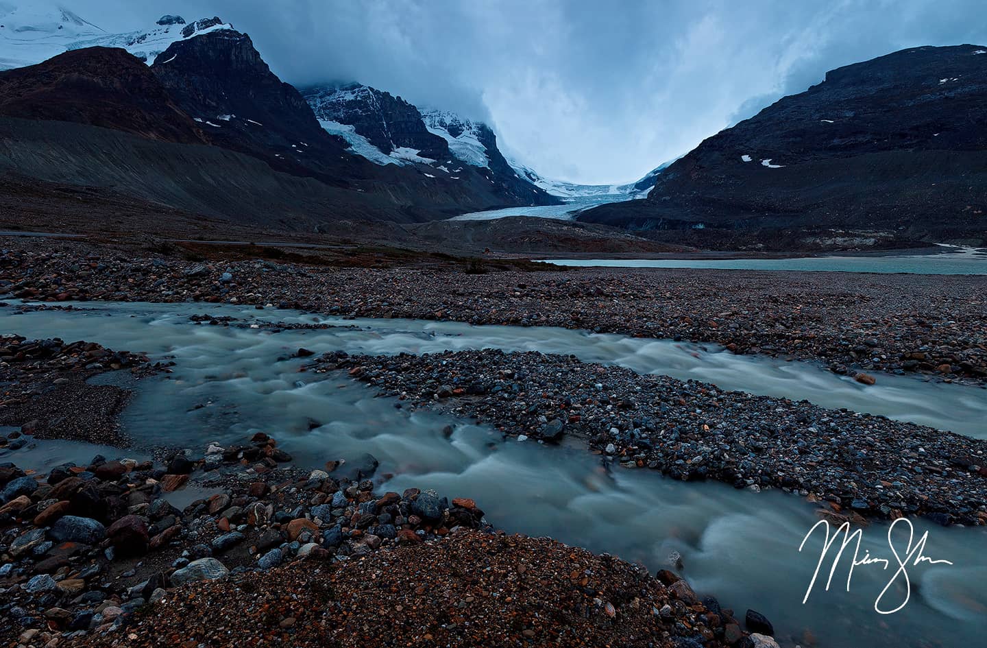
Night falls over the Athabasca Glacier at the top of the Icefields Parkway
At this point, it had become too dark to shoot anything worthwhile. I was still hoping for the weather to clear off so I could shoot a beautiful night shot at some point. I drove another mile down the road to my campsite, and made a bed in the back of the SUV. As I laid down, the rain started to come in heavier waves. I began to think this wasn’t going to let up anytime soon. I had forgotten to get a blanket in Jasper, so I added some layers of clothes and used the rest of my clothes as covers. I eventually dozed off to the sound of the rain. At some point, in what I thought was the middle of the night, I woke up shivering heavily. It was getting a LOT colder. I kept trying to go back to sleep, but would wake up over and over because of how cold I was getting. I finally gave up. I was hoping it was at least 3-4AM, and I could just start my drive down the Icefields Parkway and back across British Columbia to Bellingham, Washington where my brother would be awaiting that evening. I turned the car on. It was 1AM… But I blasted the heat and decided to start driving. I didn’t want to have to turn the car on every 2 hours to heat it up and wake the other campers up multiple times through the night. I started my drive back down the Icefields Parkway to the patter of light rain. There was to be no Athabasca Glacier Northern Lights or Milky Way scene on this trip. After 15 minutes of heat to warm me up, my tiredness set back in. There was no way I could drive the 700+ miles I had ahead of me on the amount of sleep I had. And so for the next 5 hours, I would stop at a pull-off on the Icefields Parkway to sleep an hour or two until I got cold. Then I would drive 10 miles or so with the heat on blast, and repeat the same scenario. I managed to get enough sleep by 6AM that when the mountains started to take shape from daylight, I was ready to continue on. While the rain had mostly disappeared, the clouds stuck around, making for some beautiful foggy scenes that completely rejuvenated me! I knew I was going to capture some great photos on the rest of the Icefields Parkway.
The long drive across British Columbia
As morning finally started giving light to the mountains surrounding me, the fog and clouds began to show off some amazing scenes. The first was a low-light scene of fog and extremely blue water at Waterfowl Lake, followed by Snowbird Glacier and fog swirling around the surrounding peaks.
Fog swirls in the mountains above Waterfowl Lake on the Icefields Parkway
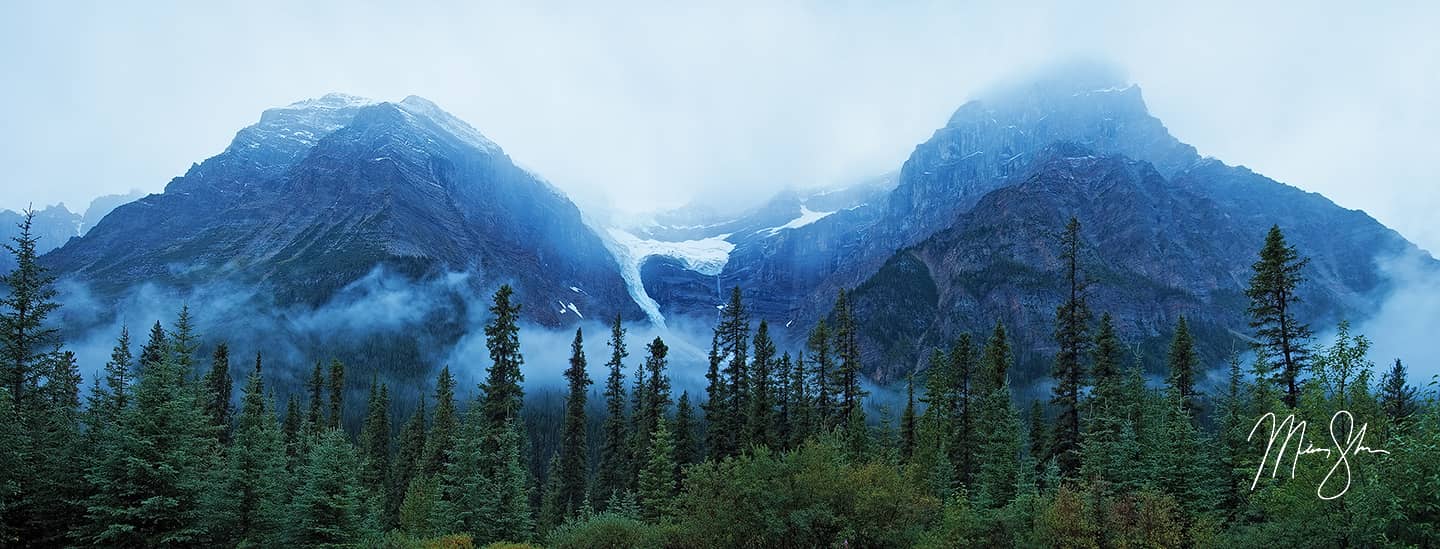
A panorama of the fog clinging to Snowbird Glacier and the mountains surrounding it
After those two quick stops, I decided to give Peyto Lake another go. While I didn’t expect the throngs of crowds from two days earlier, I did think I’d probably run into one or two others out enjoying the beautiful unique atmosphere. I was wrong, I had Peyto Lake all to myself! I walked to the viewing platform and had a blast just shooting this famous Canadian Rockies lake all by myself! I knew I couldn’t stay long, as I had a lot of stops and a lot of miles to cover, so after shooting a couple of scenes that are in the Banff National Park photo gallery, I moved on.
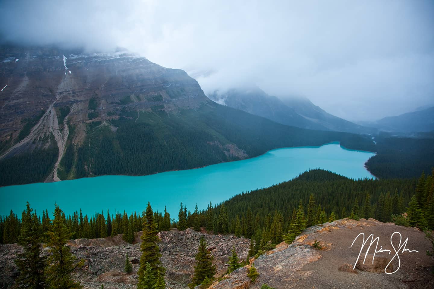
Beautiful, famous Peyto Lake shrouded in fog and clouds
Blue morning sunrise at Bow Lake in the Canadian Rockies
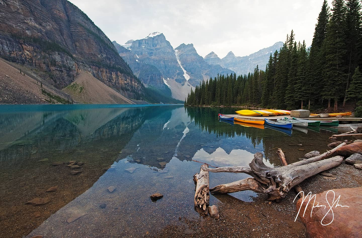
Before the turn to head towards Yoho National Park and beyond, I stopped at a pulloff near Bow Lake and shot what little of a sunrise there was that morning. The clouds partially broke and provided a little blue color in the sky. I moved on, and decided I needed to have one more visit to Moraine Lake Even though I had visited Moraine Lake 4-5 times this trip, I couldn’t help but stop by for a few minutes to see what it looked like covered in fog and clouds. By the time I got here, some of the clouds began to break apart above the Valley of Ten Peaks. While I still think my best shot of it was the sunset shot from two days earlier, it was still beautiful! I finally said goodbye to my favorite lake, vowing to return again someday. Now that I’m married, it’s places like this I can’t wait for my wife to see. It’s such a beautiful place, and easily my favorite lake in the world, as I’ve said at least once before in this blog.
I was blessed to have Peyto Lake all to myself on this foggy morning!
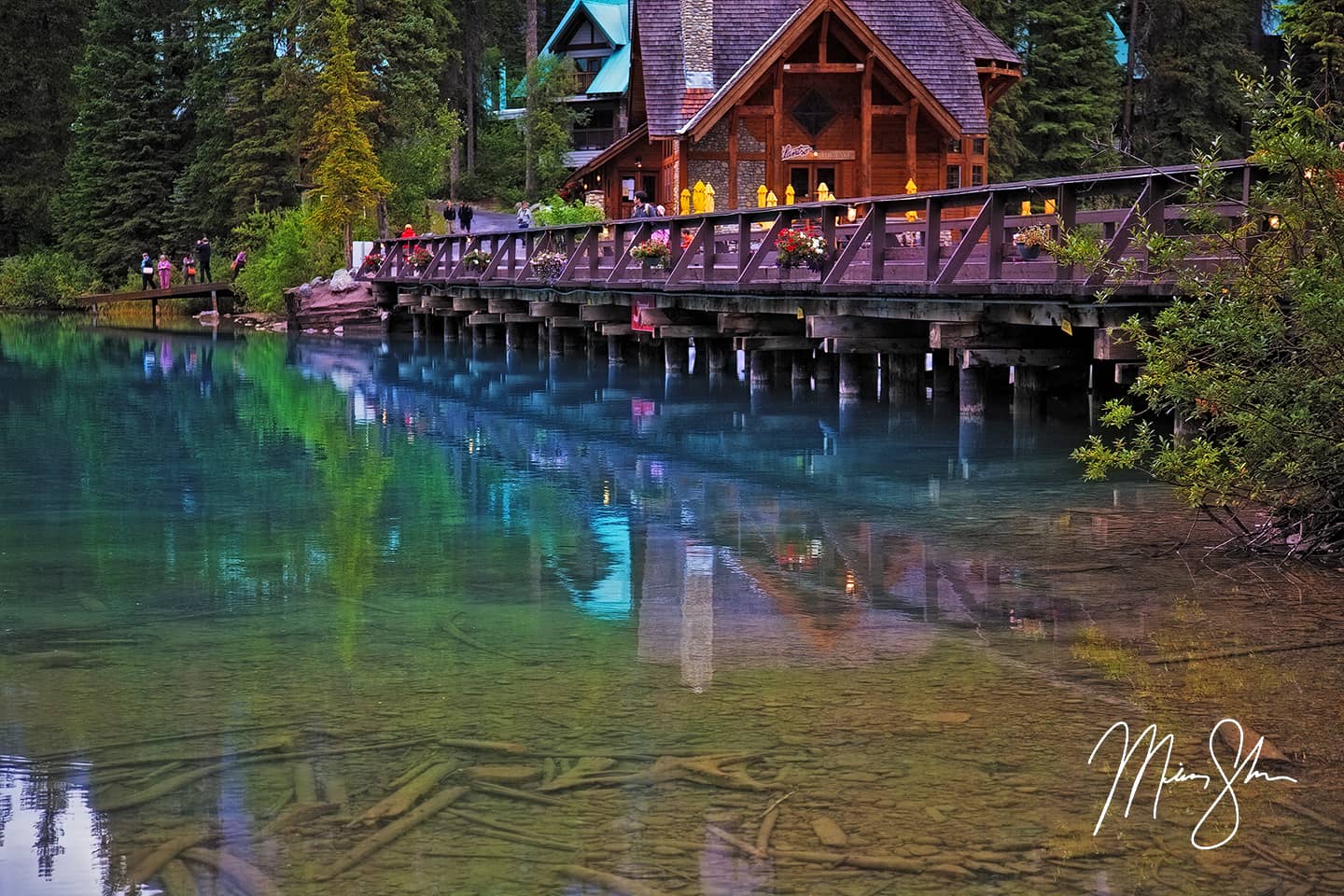
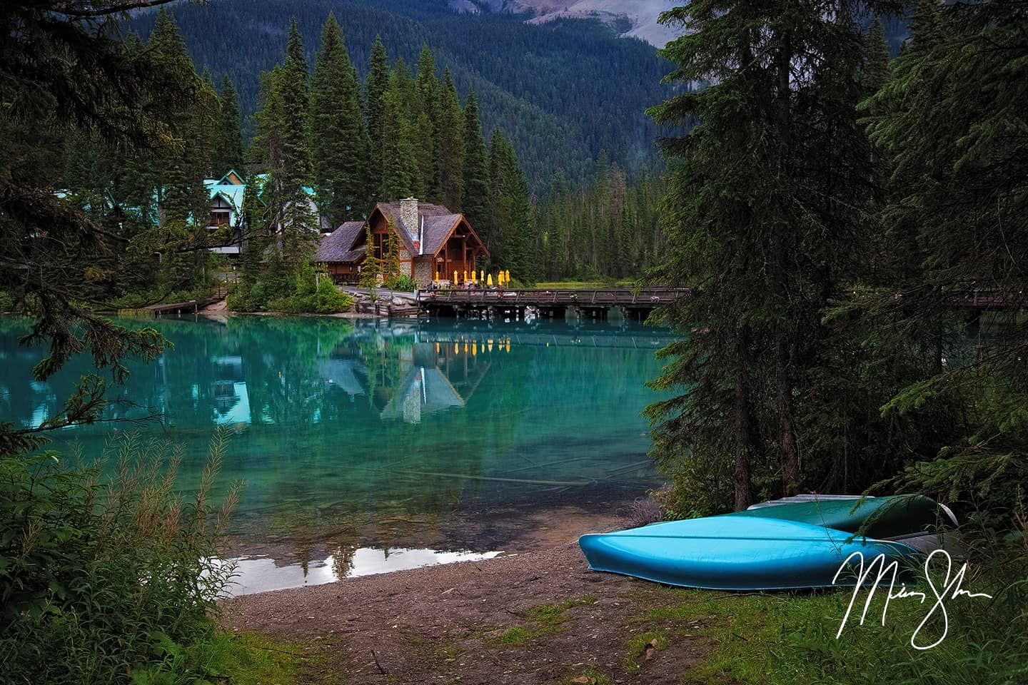
I finally tore myself away from Moraine Lake, and went back into Yoho National Park. As I had ran out of time on Monday to stop by Emerald Lake, I decided to make a quick trip up to this Yoho classic lake. I’m certainly glad I did! I captured a number of beautiful photos of a lake that was almost completely calm of wind. Beautiful reflections of the mountains around the lake mirrored on the aquamarine-colored water. Maybe it was due to the weather on the day I was there, but this lake almost rivaled Moraine Lake in beauty. Almost. A number of canoes lined the west side of the lake, and a bridge crossed over the Emerald Lake Lodge, which I’m sure would be an awesome place to have a romantic getaway with my wife someday! I wandered around the west side of the lake, and then across the bridge, snapping a number of different vantage points of the lake.
Calm waters create a beautiful reflection on an overcast day at Emerald Lake
A beautiful, overcast morning at Emerald Lake reveals one of the Canadian Rockies finest locations!
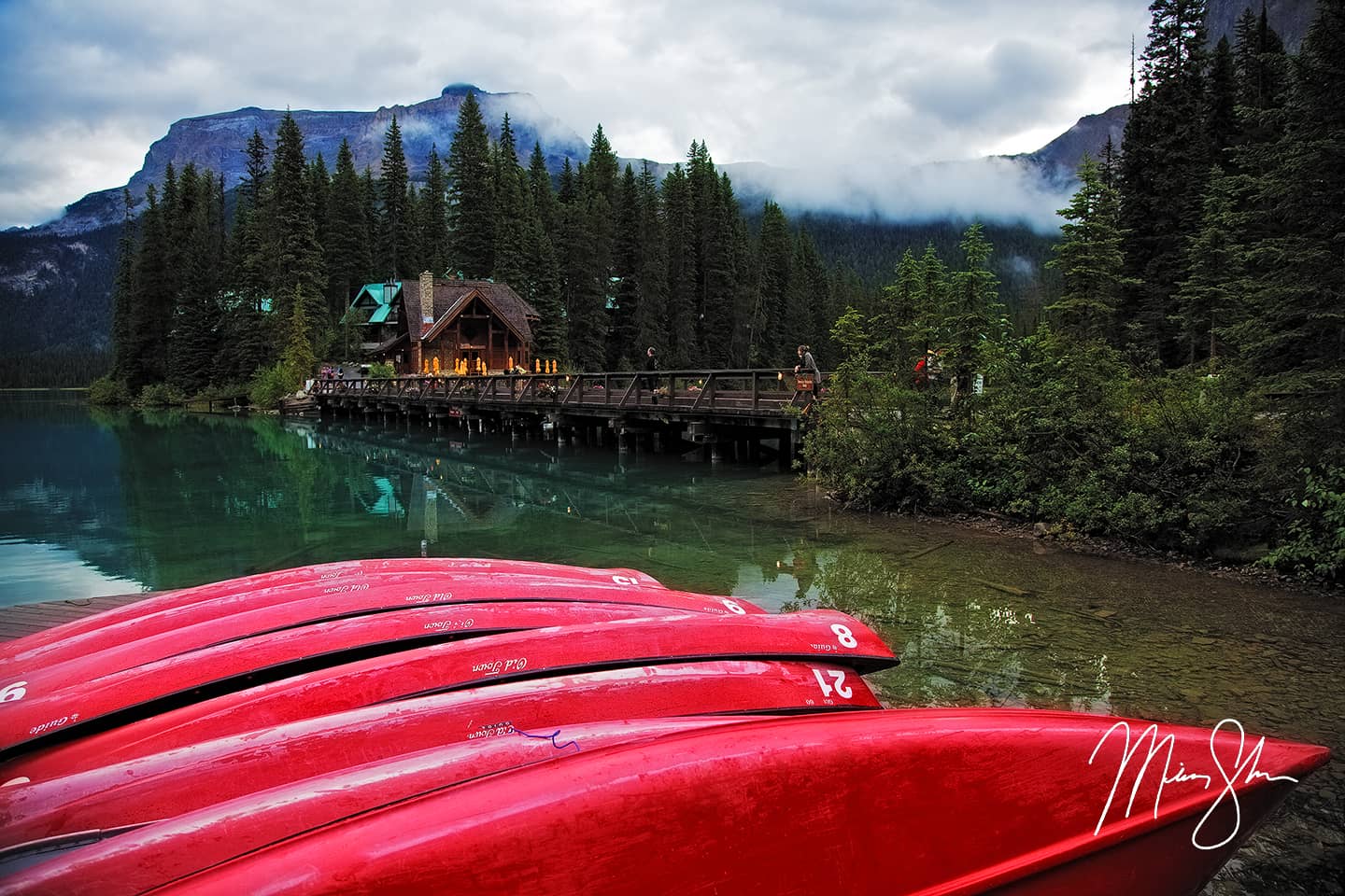
Canoes stacked at the banks of Emerald Lake in Yoho National Park
Beautiful flowers line the bridge at Emerald Lake
After leaving Emerald Lake, I realized I was starving. I had been living off of fruit, granola bars and two stops at Subway since Sunday morning, and decided to grab something to eat in Golden, British Columbia to the west of Yoho National Park. I made my first stop at Tim Horton’s and grabbed a late breakfast. I can see why this is a Canadian favorite. It was my only experience on this trip, but on my next trip to Canada, visiting Vancouver and Vancouver Island, my wife and I stopped on many occasions for a quick Tim Horton’s fix!
Beyond Golden was two lesser visited Canadian Rockies National Park’s: Glacier National Park and Revelstoke National Park. I really didn’t know much about Canada’s Glacier National Park, and so my only stop was to shoot a photo of a giant chunk of snow that hadn’t melted, even though it was the end of August.
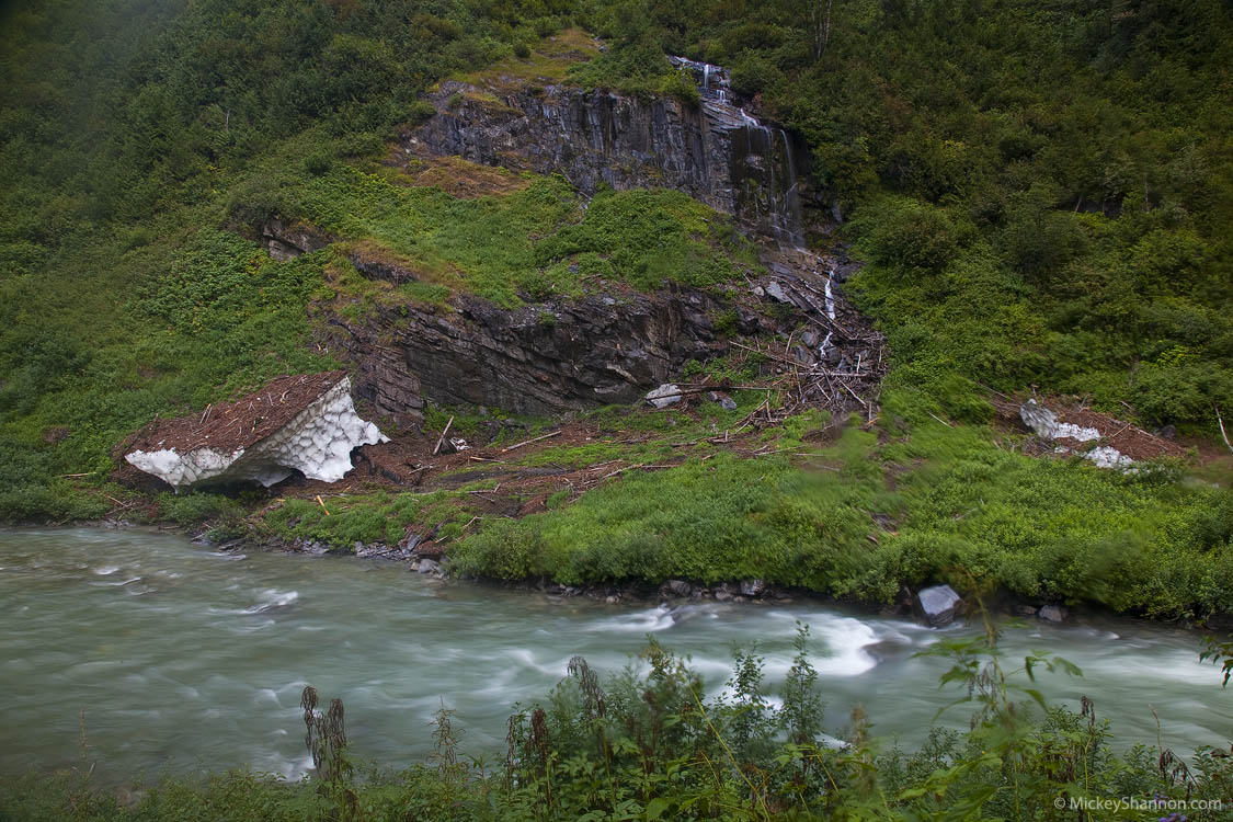
Chunk of snow on the side of the road in Canada’s Glacier National Park
I drove through Glacier National Park and eventually arrived at the edge of Revelstoke National Park. I saw a sign for the Giant Cedar’s trail. I really hadn’t read about this in my pre-trip research. Everything I read about Revelstoke had been about the amazing summer wildflowers. I decided to stop and walk the boardwalk with other tourists who were braving the light rain that had re-appeared. The Giant Cedar’s trail reminded me a little of my roadtrip through the Redwoods earlier in the year. Giant ancient groves of forest in the middle of a mountain paradise!
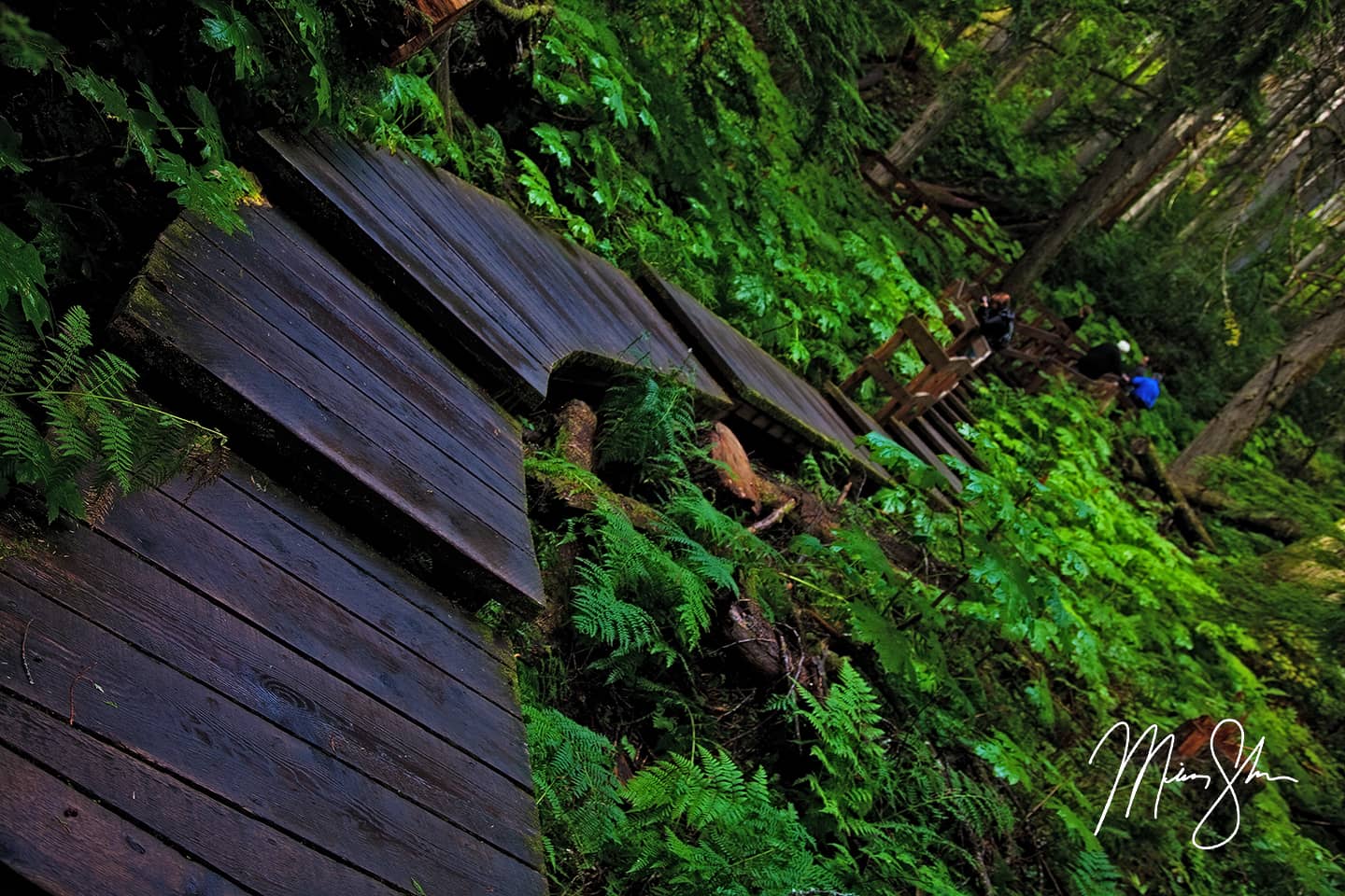
A rain-soaked boardwalk cuts through Revelstoke National Park’s ancient Giant Cedars grove
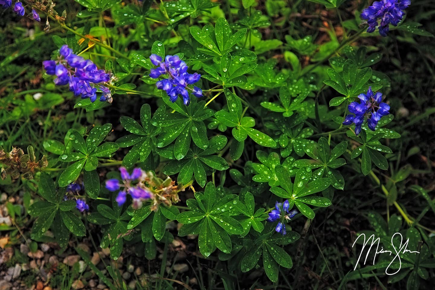
After walking the boardwalks through the Giant Cedar’s trail, I continued on to Mount Revelstoke. It takes about 30 minutes to drive up the switch-back laced Sky Parkway to the summit of Mount Revelstoke, where for 2-3 months of the year, the snow on the mountain summit melts and beautiful summer wildflowers bloom. I’m not sure if I was there during the very peak, but the flowers at the end of August were beautiful! The rain had just stopped and the sun was beginning to peak through. As it was mid-day, the best shots were close-ups of the dew still hanging to vivid purple flower pedals.
One of Canada’s premier places to see summer wildflowers is Revelstoke National Park
A closeup of some purple flowers at Revelstoke National Park
I already knew I had spent more time hiking around the wildflowers than I meant to. I had hoped to be well into the mountains north of Vancouver by sunset, and I had a decent drive still to even get to Lillooet on the edge of the coastal mountains. I left Revelstoke and continued west across British Columbia, only stopping for gas at Kamloops on the way. I drove along the edge of Kamloops Lake on highway 1, then turned onto highway 97, seeing signs for Prince George. This again made me dream of that road trip to the Salmon Glacier and northern British Columbia! Someday, I’ll make that trip a reality. I continued on, turning onto highway 99, crossing through Marble Canyon Provincial Park and Pavilion Lake before finally arriving in Lillooet. The “highways” at this point had turned into narrow two-lane roads at times, which had a number of one-lane bridges to alternate who got to cross them. The views were pretty spectacular. Lots of canyons, with mountains surrounding in every way. The mountains to the west were much larger. Byt the time I arrived in Lillooet, it was getting to be late afternoon. I stopped at Seton Lake, on the west edge of Lillooet, hoping to get a great shot of the lake, but the light was difficult to work with and I still had a ways to drive. I snapped the shot below and continued on towards Whistler and Vancouver.
View across Seton Lake at late afternoon
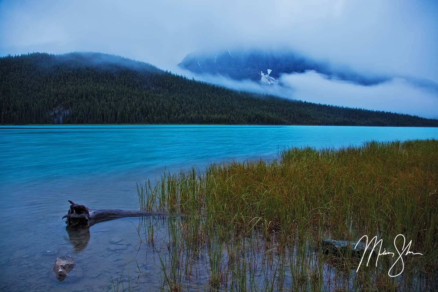
After passing Lillooet, and as I climbed higher into the mountains that stretched to the Pacific Ocean, the clouds and rain began to take over again. It was also beginning to get dark. The rain seemed to enhance the beauty of the place. Deep, dark forests, high peaks and beautiful lakes like Duffey Lake filled the scenery! I made a stop on the shores of Duffey Lake twice to snap the following two images.
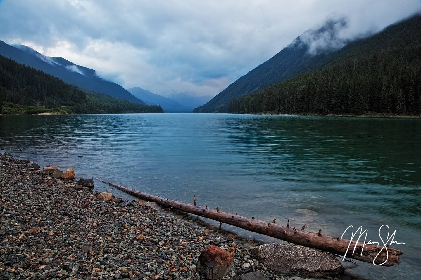
Shoreline at Duffey Lake between Lillooet and Whistler.
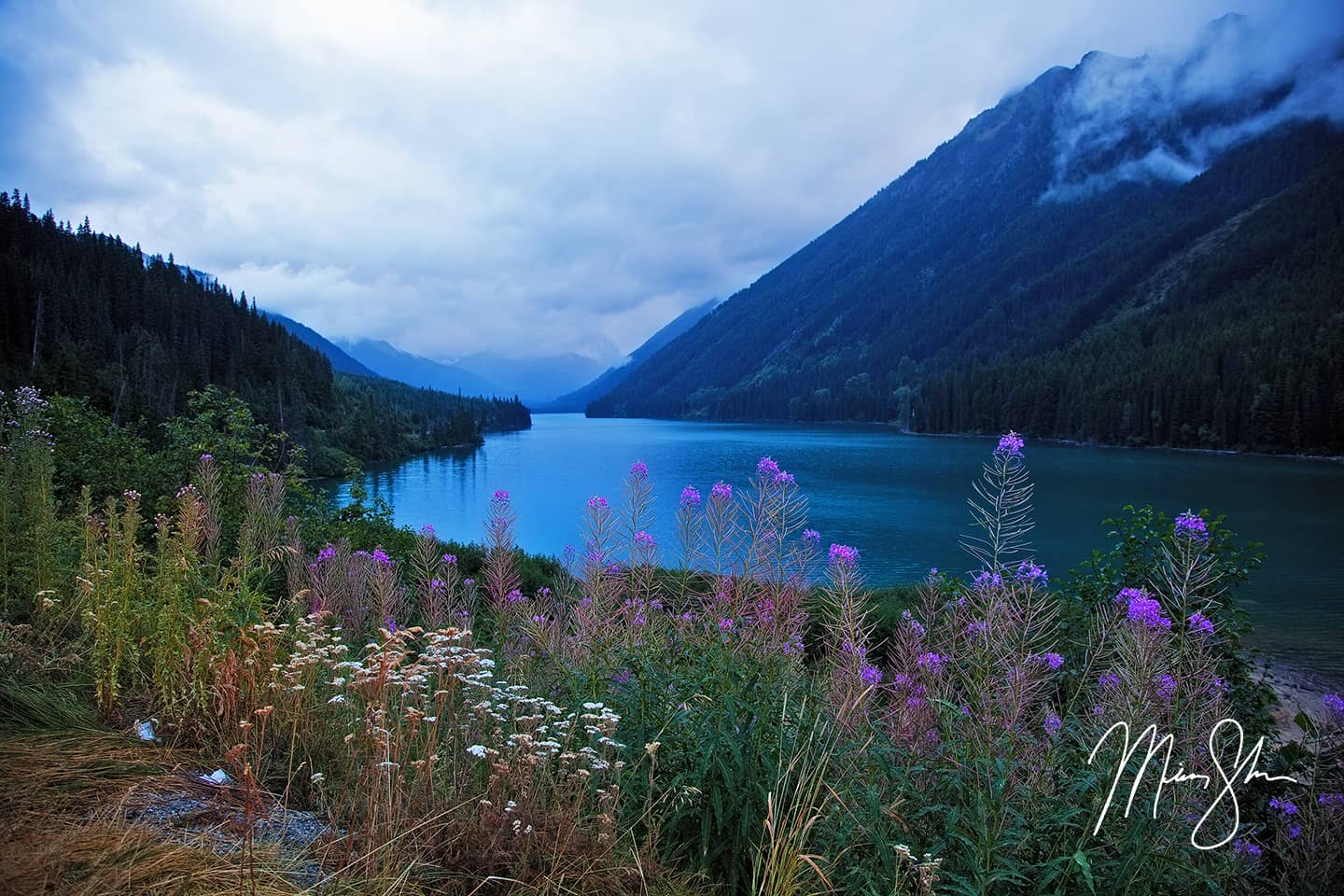
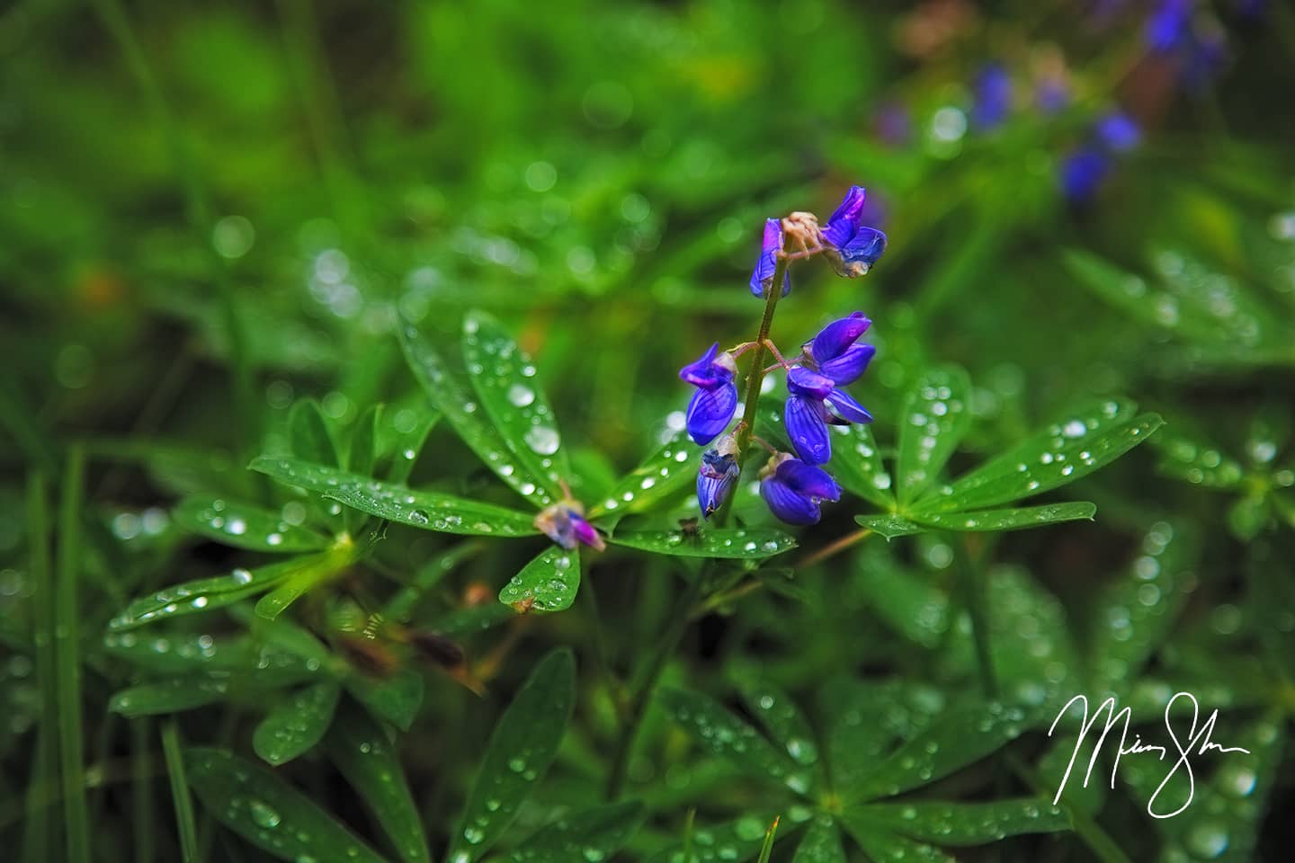
Beautiful flowers line the lake at Duffey Lake on an overcast day
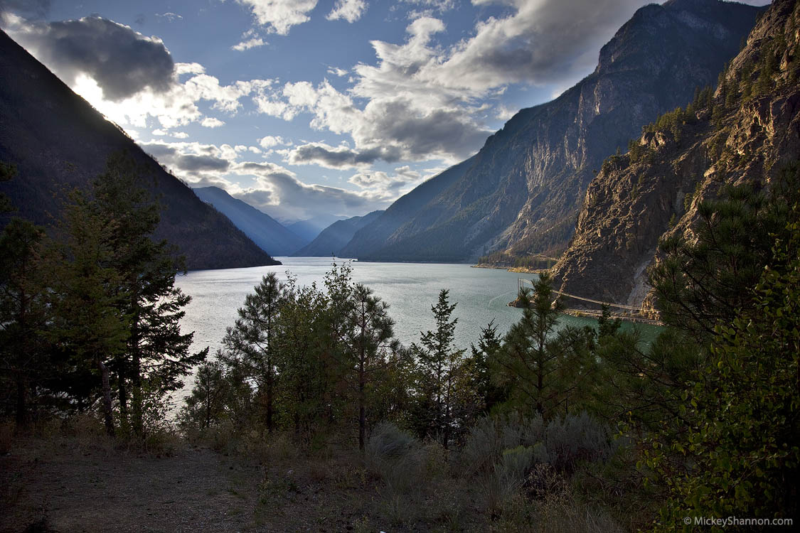
After grabbing some shots at Duffey Lake, I continued towards Pemberton and Whistler. At one point, somewhere near Cayoosh Pass, I knew I needed to get out and get one more shot of the weather before darkness fully set in. There was to be no sunset on this evening. But the unique atmosphere during this drive through the coastal mountains of British Columbia was an amazing experience summed up in the photo below.
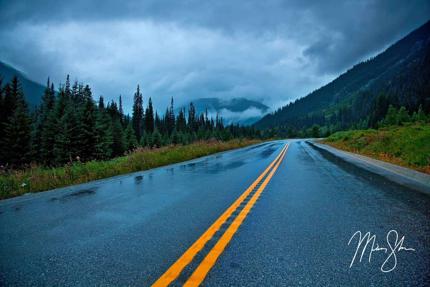
Driving coastal Canada near Duffey Lake
As darkness set in, the beautiful views of the rest of highway 99 and the Sea to Sky Highway towards Vancouver were covered. I drove through Pemberton and Whistler well after dark, and eventually the lights of Squamish came into view. I drove the rest of the Sea to Sky Highway, going up and down from sea level to views out over the Howe Sound showing the lights out on islands and across the sound towards Bowen Island and what I assume might have been Gibsons on the Sunshine Coast. I was completely exhausted at this point. I had always planned to do the much longer drive through Lillooet down the Sea to Sky Highway instead of taking the much shorter route down Highway 1 to Bellingham, Washington. I wanted to see and photograph this area. While it was dark for the majority of it, even getting the three photos above was worth the extra time. This route added another 3 hours to what turned into about 18 hours of driving and stopping along the way from the top of the Icefields Parkway to crossing the US border and my hotel bed in Washington. But all that extra time and exhausted-ness was worth it. I somehow found my way through Vancouver, down to the US border crossing, arriving at my hotel around midnight.
The rest of this trip explored Olympic National Park, Mount Rainier National Park and the Columbia River Gorge. That will be a story for another time. Before I get back to this part of the trip, I’ll be back with a travel blog about our recent trip to Vancouver and Vancouver Island.